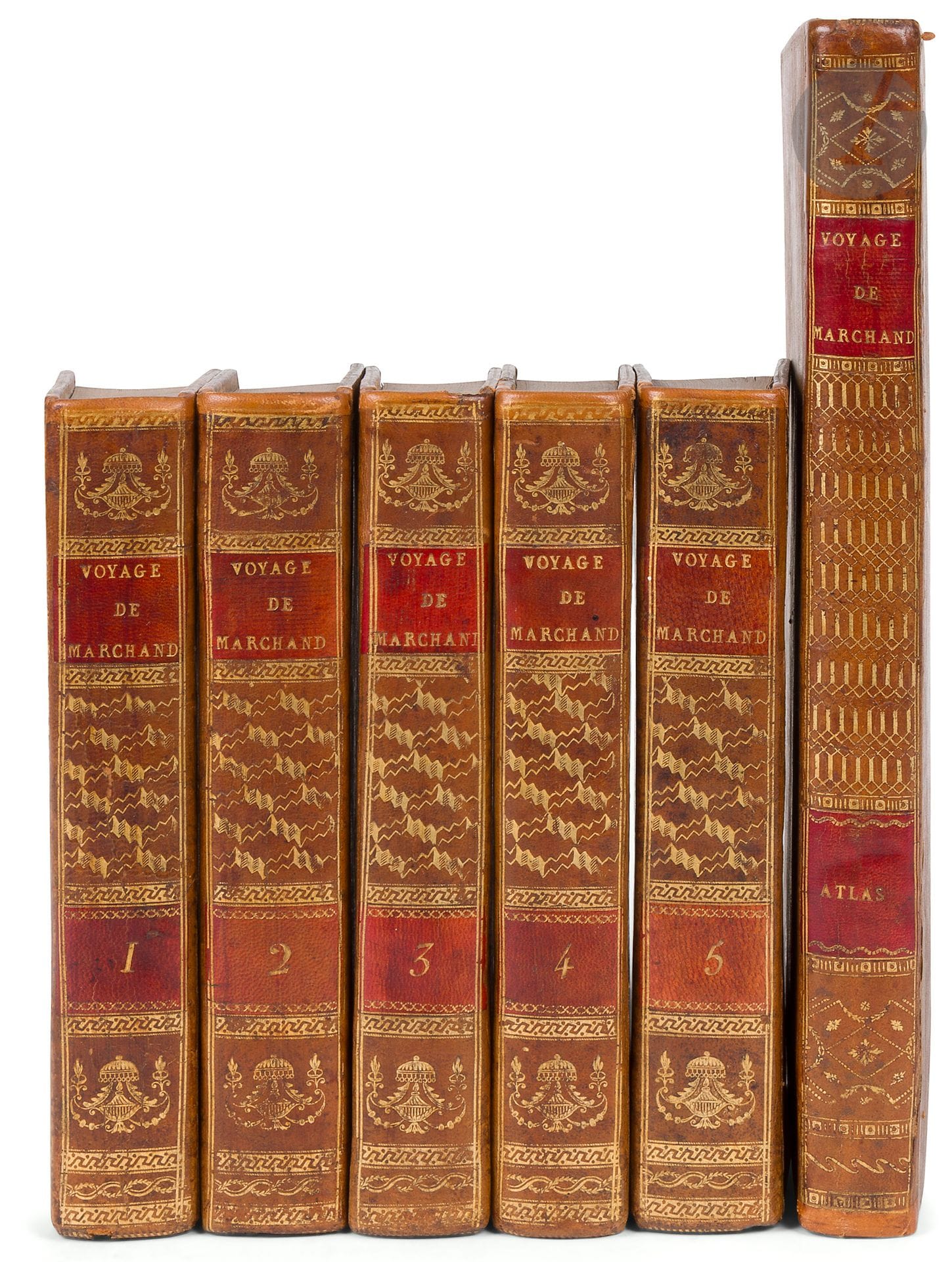
MARCHAND (Étienne). Voyage autour du monde, pendant les années 1790, 1791 et 1792... précédé d'une introduction historique ; auquel on a joint des recherches sur les terres australes de Drake, et un examen critique du voyage de Roggeween. Paris : imprimerie de la République, An VI-VIII [1798-1800]. -5 volumes in-8, 195 x 122 and an atlas in-4 : (2 ff.), viij, ccj pp., (1 f.), 294 pp., (1 f.) ; pp. (iii)-vij, 529 pp., 2 tables; (1 f.), viij, 474 pp. (1 f.), 4 tables; viij, 494 pp. (1 f.): xij, 559 pp. (2 ff.); (1 f.), viij, 158 pp. (1 f.), 15 maps, 1 plate. Basane racinée, gilt roulette framing the boards, smooth spine decorated, marbled edges (period binding). Sought-after first edition of the account of the round-the-world voyage of navigator Étienne Marchand (1755-1793), published and written by explorer and hydrographer Charles-Pierre Claret de Fleurieu (1738-1810). It appeared simultaneously in in-8 and in-4 format. Marchand sailed around the world as captain of the Solide from 1790 to 1792, with the aim, among other things, of establishing a fur trade between North America and China. While the voyage proved a commercial failure, it was a true scientific success. It enabled first-rate geographical observations to be made, notably on the coasts of Australia and New Guinea, and contributed to our knowledge of these regions, which were largely unknown in Europe at the time. This was the second successful circumnavigation by the French, following Bougainville's voyage between 1766 and 1769. Fleurieu based his account on the journals of Prosper Chanal (1763-1830), the ship's first mate, and surgeon Claude Roblet (1758-1809). He wrote a long and very interesting introduction, including an "Abridged History of the Progressive Discovery of the North-West Coast of America, from 1537, when Cortes discovered California by sea, to 1791, when Captain Marchand landed on this Coast at the fifty-third parallel". This introduction was read at the sessions of the Institut National des Sciences et des Arts, classe des sciences morales et politiques, on July 5 and 10, 1797. Volume IV and part of Volume V are devoted to the "Histoire naturelle des Oiseaux, des Poissons, des Cétacées, des Amphibies, et des Plantes et autres Productions marines, que le Solide a rencontrés à la mer dans sa Circonnavigation du Globe". Volume V also includes "Recherches sur les îles et le Port découverts par Sir Francis Drake, en 1578, dans le Grand Océan Austral", as well as a "Examen critique des Relations du Voyage autour du monde, en 1721 et 1722, par l'Amiral hollandais Roggeween". Copy complete with atlas comprising 15 folding maps and one plate. This is the same as the one that accompanies the in-4 edition. It is not simply a collection of charts, but also contains 150 pages of "Observations sur la Division Hydrographique du Globe..." and a long chapter on "Application du système métrique décimal à l'hydrographie et aux calculs de la navigation". The text volumes include 10 fold-out tables, 6 out of the text and 4 included in the pagination (volume 3). A fine copy in contemporary binding. The spine of the atlas is decorated differently, but the binding comes from the same workshop, the boards being identical to those of the text volumes. Bindings very skilfully restored, some rubbing and scuffing on the atlas boards.
Estimate
€2,000 - €3,000
Result
€2,274
Buyer's premium
26%
MARCHAND (Étienne).
Voyage autour du monde, pendant les années 1790, 1791 et 1792... précédé d'une introduction historique ; auquel on a joint des recherches sur les terres australes de Drake, et un examen critique du voyage de Roggeween.
Paris : imprimerie de la République, An VI-VIII [1798-1800]. -5 volumes in-8, 195 x 122 and an atlas in-4 : (2 ff.), viij, ccj pp., (1 f.), 294 pp., (1 f.) ; pp. (iii)-vij, 529 pp., 2 tables; (1 f.), viij, 474 pp. (1 f.), 4 tables; viij, 494 pp. (1 f.): xij, 559 pp. (2 ff.); (1 f.), viij, 158 pp. (1 f.), 15 maps, 1 plate. Basane racinée, gilt roulette framing the boards, smooth spine decorated, marbled edges (period binding).
Sought-after first edition of the account of the round-the-world voyage of navigator Étienne Marchand (1755-1793), published and written by explorer and hydrographer Charles-Pierre Claret de Fleurieu (1738-1810). It appeared simultaneously in in-8 and in-4 format.
Marchand sailed around the world as captain of the Solide from 1790 to 1792, with the aim, among other things, of establishing a fur trade between North America and China. While the voyage proved a commercial failure, it was a true scientific success. It enabled first-rate geographical observations to be made, notably on the coasts of Australia and New Guinea, and contributed to our knowledge of these regions, which were largely unknown in Europe at the time. This was the second successful circumnavigation by the French, following Bougainville's voyage between 1766 and 1769.
Fleurieu based his account on the journals of Prosper Chanal (1763-1830), the ship's first mate, and surgeon Claude Roblet (1758-1809). He wrote a long and very interesting introduction, including an "Abridged History of the Progressive Discovery of the North-West Coast of America, from 1537, when Cortes discovered California by sea, to 1791, when Captain Marchand landed on this Coast at the fifty-third parallel". This introduction was read at the sessions of the Institut National des Sciences et des Arts, classe des sciences morales et politiques, on July 5 and 10, 1797.
Volume IV and part of Volume V are devoted to the "Histoire naturelle des Oiseaux, des Poissons, des Cétacées, des Amphibies, et des Plantes et autres Productions marines, que le Solide a rencontrés à la mer dans sa Circonnavigation du Globe". Volume V also includes "Recherches sur les îles et le Port découverts par Sir Francis Drake, en 1578, dans le Grand Océan Austral", as well as a "Examen critique des Relations du Voyage autour du monde, en 1721 et 1722, par l'Amiral hollandais Roggeween".
Copy complete with atlas comprising 15 folding maps and one plate. This is the same as the one that accompanies the in-4 edition. It is not simply a collection of charts, but also contains 150 pages of "Observations sur la Division Hydrographique du Globe..." and a long chapter on "Application du système métrique décimal à l'hydrographie et aux calculs de la navigation". The text volumes include 10 fold-out tables, 6 out of the text and 4 included in the pagination (volume 3).
A fine copy in contemporary binding. The spine of the atlas is decorated differently, but the binding comes from the same workshop, the boards being identical to those of the text volumes.
Bindings very skilfully restored, some rubbing and scuffing on the atlas boards.
Sale
Wednesday 5 March 2025・14:30 (Europe/Paris)
Sale location coming soon
3, rue Favart
75002 Paris