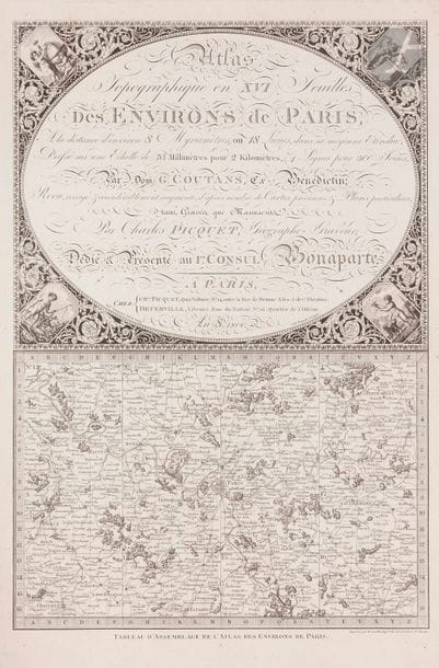
PICQUET (Charles) - COUTANS (Guillaume). Topographic Atlas in XVI sheets of the surroundings of Paris, At the distance of about 8 Myriameters, or 18 Leagues, in its average Extent, Drawn up on a Scale of 31 Millimeters for 2 Kilometers, (4 Lines by 300 Toises)... Reviewed, corrected & considerably increased, according to many precious Maps & Particular Plans, both Engraved and Manuscripts. Paris : Charles Picquet, Deterville, An 8, 1800 - In-folio, 463 x 339 : title, 16 cards. Sheets. Beautiful fully engraved atlas consisting of a leaf with the title in its upper part and the assembly plan of the atlas in its lower part, followed by the 16 double-page maps showing Paris in the center and its surroundings from Gisors and La Ferté-Milon in the North to Chartres and Provins in the South. This atlas is the work of the geographer and Benedictine of the Congregation of Saint Maur Dom Guillaume Coutans. It first appeared in 1775. It has been here revised and augmented by the geographer and engraver Charles Picquet. Good sheet copy, well preserved despite tears repaired on cards 5, 12 and 13. Some dirt on the edges of the sheets.
Estimate
€400 - €500
Result
Not sold
Buyer's premium
28%
PICQUET (Charles) - COUTANS (Guillaume).
Topographic Atlas in XVI sheets of the surroundings of Paris, At the distance of about 8 Myriameters, or 18 Leagues, in its average Extent, Drawn up on a Scale of 31 Millimeters for 2 Kilometers, (4 Lines by 300 Toises)... Reviewed, corrected & considerably increased, according to many precious Maps & Particular Plans, both
Engraved and Manuscripts.
Paris : Charles Picquet, Deterville, An 8, 1800 - In-folio, 463 x 339 : title, 16
cards. Sheets.
Beautiful fully engraved atlas consisting of a leaf with the title in its upper part and the assembly plan of the atlas in its lower part, followed by the 16 double-page maps showing Paris in the center and its surroundings from Gisors and La Ferté-Milon in the North to Chartres and
Provins in the South.
This atlas is the work of the geographer and Benedictine of the Congregation of Saint Maur Dom Guillaume Coutans. It first appeared in 1775. It has been here revised and augmented by the geographer and engraver Charles
Picquet.
Good sheet copy, well preserved despite tears repaired on cards 5, 12 and 13. Some dirt on the edges of the sheets.
Sale
Tuesday 3 March 2020・14:00 (Europe/Paris)
Sale location coming soon
3, rue Favart
75002 Paris